As a Louis Dreyfus-Weidenfeld Scholar for Masters of Public Policy (2015-16), I had the unique opportunity to work on themes of conflict prevention during my summer project at The World Bank. I learnt through my work that natural resources including water resource remains one of the leading dimensions in todays conflict. Sometimes the intensity of the conflicts is so low in terms of violent deaths that our peace building efforts exclude them. This exclusion leads to circumstances where conditions of positive peace remain low and consequently , these disputes culminate in a sense of deprivation leading to violent eruption of conflicts. Even during the time, when the conflicts remain dormant, they still lead to stalled development and worse living conditions for conflict affected people.
According to Global peace index, 2017, Pakistan is the least peaceful country in the South Asia ranking 152 out of the 163 countries at the index. It is very important to reduce all kinds of violence and not only build peace but preempt conflict. Positive peace can only be achieved through inclusive sustainable development. Access to water remains one of the biggest dimensions of the conflicts in 21st century. (WorldBank) especially in Agro based economies like Pakistan.
Arid or “Barani” areas in Pakistan are referred to as region with no supply of canal irrigation water, whose agriculture is dependent upon erratic rainfalls. Arid region in Pakistan contributes into national agricultural production by 10%.
The Province of Punjab, Pakistan has 51 million acres geographical area out of which 18.6 million acres is comprised of Punjab Barani Tract (PBT). Despite being endowed with Indus River System, Pakistan is heading towards becoming a water scarce country as annual per capita water availability has sharply declined (reduced from 5,000 m3 in 1950 to a current low of less than 1000 m3), primarily because of population growth and climatic factors. The Barani Tract of the Punjab is no exception as the tract has mostly ephemeral rivers with flash floods in the hilly tracts; the few perennial rivers have very low flows. Moreover, Institutional responsibilities for regulating water management and service delivery are scattered through plethora of institutions both at federal and provincial levels with very little coordination.
The limited water is stored in water reservoirs and used by individual farmers and communities. Government in the recent past has been active in providing water reservoirs to the people. However, due to the conditions like large land holdings and individual farmers, it is very common for the communities to get embroiled into communal conflicts over access to water, water usage rights etc. Although dispute resolution mechanisms are incorporated into government and farmer agreement but usually it fails to resolve conflict as the current conflict reporting systems are paper based and take a very long time to reach the existing dispute resolution systems.
These communal conflicts subsequently lead to continual violence and generation long rivalries. In the process, farmers get bogged down in cumbersome legal procedures without access to informal and formal dispute resolution mechanisms. These conflicts lower agriculture yield, extend drought periods propelling farming communities into a poverty trap and nullifying the intended impacts of agricultural interventions.
Upon my return to Pakistan, I chose to work in the water resource development sector in climate change prone arid areas of Punjab province of Pakistan. I now hold a unique position of a government official who is working in a traditionally non-government development sector in Pakistan. Government of the Punjab province of Pakistan is embracing technology at a remarkable pace. As a part of one such initiative, We at our organization, Agency for Barani Areas development (ABAD) have established a Geographical Information Systems Lab to map water interventions in the arid areas of Punjab. This initiative in itself is one of its kind in Punjab. Being a lead for this project and having access to the area and information. I was astonished to discover that there is no formal database for the water disputes arising around water bodies in rain dependent areas of Punjab, Pakistan. With generous support of Build Peace Fellowship I have been able to develop a GIS based water dispute resolution management system. This initiative will use the geographical mapping of the water disputes and use the information to facilitate and support existing dispute resolution mechanisms in the arid areas. The Intervention aim to use the mix of technology and Community-based participatory research (CBPR) to devise a GIS based water dispute resolution management system for prevention and resolution of communal conflict in farming communities.
A Prototype has been developed and will be launched as a pilot in April 2018 in arid areas of Punjab.
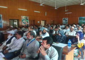
Picture above shows the farmer sessions that help involve them in the development of this system.
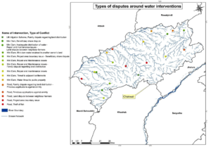
The following map shows different queries e.g different types of conflicts, status of conflicts, intensity of conflicts, number of conflicts etc. Along with this, with the help of GIS software one can apply different queries of his own choice for doing different analysis.


